

More Comments on Dungeness River Water Flow
Bullet Point Summary:
- The current river flow is so low that it has fallen off the graph. It’s below the “Extremely Below” level and is continuing downward.
- The old days of summer snowpack melt and runoff are ending. We can look forward to low water flow in the dry season.
Details:
Statistical Graph:
The first graph is the USGS statistical graph of the historical river flow, dated August 12, 2026.
https://waterdata.usgs.gov/monitoring-location/USGS-12048000/statistical-graphs
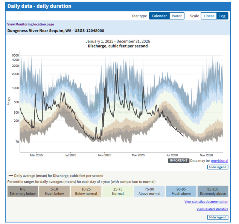
This graph has two plots. The background plot is a statistical plot of the day-by-day water flow over a 100-year history. The statistics are color coded, from low flow (“Extremely below”) (0-5%) to high flow (“Extremely above”) (95-100%).
The dark line in the graph is a plot of the recorded daily water flow starting in January 2025. The latest days of water flow has “fallen off the graph”, so to speak. This implies that a significant history-changing event is presently underway. In my opinion, this is the graph to monitor in the coming weeks.
Current flow vs. Average Flow
The graph below is taken from the USGS web site, dated August 12.
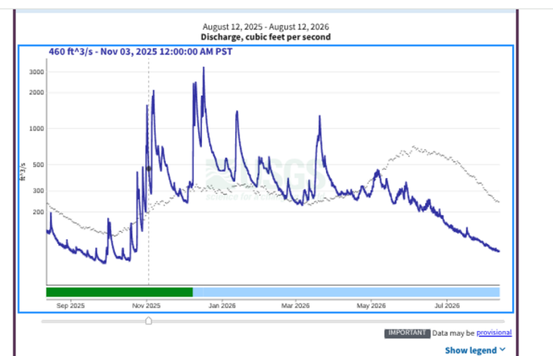
The dark blue plot is the daily river flow from August 12, 2025, to August 12, 2026, 1 year in length. The fainter dotted line in the background is a plot of the 100-year average river flow for each given day in the year. These two plots suggest the following:
- The grayish light-colored plot:
- There is a late summer dry spell when the river flow decreases.
- The winter precipitation season starts in late October and lasts until approximately March. Historically the river low gradually increases and peaks at about 300cfs before decreasing modestly.
- The snowpack runoff season begins in late March and continues until the winter season starts back up. The snowpack runoff increases steadily in early summer and peaks out at approximately 650cfs in June. This period has historically been the highest river flow, almost twice as high as the flow in the winter. The snowpack declines through the rest of the summer until the beginning of the next “wet” season.
- The dark blue plot:
- Late last summer and early fall, this year’s flow was significantly below average. Things are drier than normal.
- Winter shows an entirely different story: There are numerous large spikes of runoff, significantly exceeding the historical average. These spikes continue all through the wet season.
- This implies that due to warmer temperatures, much of winter’s precipitation occurred as rain and ran off immediately. This also implies significantly lower snowpack. This high winter runoff resulted in record flooding elsewhere in the Cascades.
- During the “snowpack runoff season”, there is a slight peak and then a significant and steady decline in river flow.
- This is probably not a 1-time event but is now the new normal. The data from the previous year is similar to this year.
Conclusion: Because of climate change, with warmer temperatures, we can expect more rainfall and less snowpack in the mountains in the winter. This will result in low and decreasing river flow in the dry months. This will mean less water for salmon runs, municipal water supplies and irrigation during the summer months. This also implies lower water levels in the underground aquifers during these dry months also.
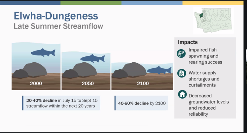
(Slide taken from Washington State Department of Ecology water webinar, August 4, 2026.)
The “Good Old Days” are over.
REPLY TO A CCWD ARTICLE
Posted 8-8-26
Drought or Déjà Vu? The answer is both.
This article is a critique of CCWD Dungeness River Flow post dated July 7, 2026. https://www.ccwatchdog.com/p/drought-or-deja-vu-what-the-dungeness?utm_source=publication-search
The data presented in this CCWD report does not support the article's conclusions.
What is really suggested by their graphs is that climate change has come to the Olympic Peninsula and is beginning to cause significant reductions in the summer flow of the Dungeness River. These flow reductions are going to get worse in the future.
The Graphs:
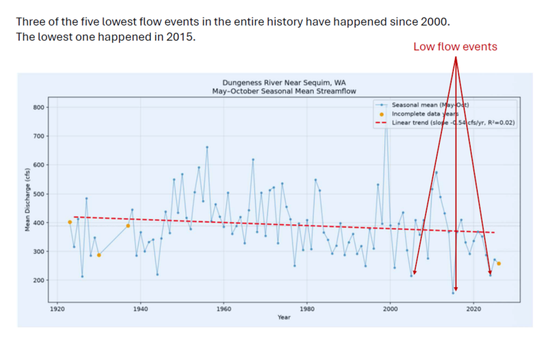
Let’s have a look at the first graph: the “Seasonal Mean Streamflow”.
Now let’s look at the second graph, the “Hydrograph”:
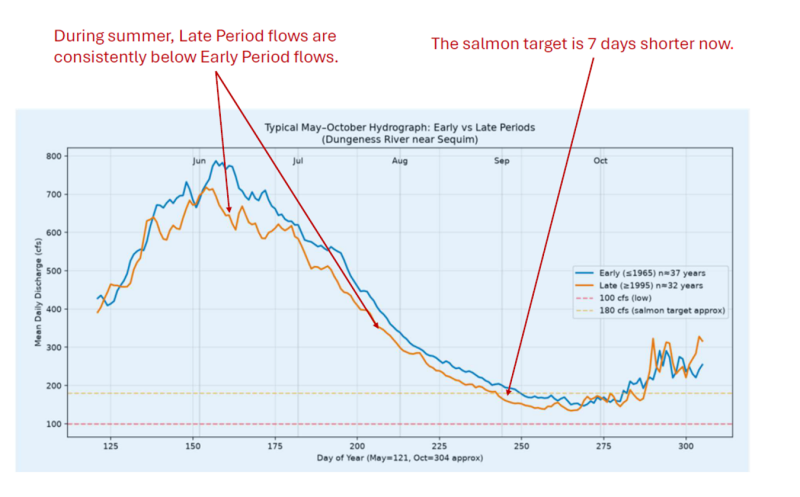
Regarding the third graph, the “Key Low Flow Thresholds” (not shown here):
The three driest low-flow events happened after 2000. Furthermore, the driest event in the 100-year record happened in 2017.
Now for a plot of my own: Below is plot of Dungeness River discharge. This plot shows the stream flow this year, the stream flow last year and the 100-year average stream flow. This year’s flow (about 100cfs) is only a third of the 100-year average, about 300cfs.
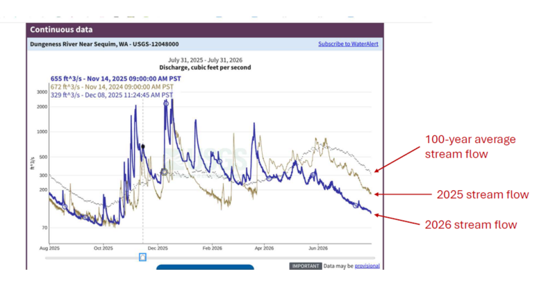
The present stream flow is now even below the “Extremely Below” 100-year statistical level.
Go here to see the graph: https://waterdata.usgs.gov/monitoring-location/USGS-12048000/statistical-graphs
What is really happening?
This past winter the Olympic Mountains and the entire northern Cascade Mountains had an unusually warm winter and most of the winter’s precipitation fell as rain and ran off. This caused record flooding of the Snoqualmie River among other things. https://www.fox13seattle.com/weather/wa-rivers-hit-record-levels
This left an unusually low snowpack which was reported by the Washington Department of Ecology.
This dismal snowpack is resulting in unusually low levels of river flow this summer.
The present drought conditions, reported by the Federal Drought Information System, will most likely fail to restore normal stream flow for the rest of our dry season.
Here is a slide showing Washington state drought conditions for the last 5 years.
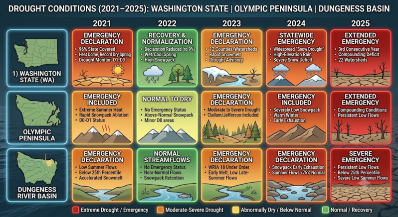
Climate Change is real and here to stay.
Climate change is bringing warmer winters with less snowpack and hot dry summers with increasingly serious wildfire hazards, as everybody in Spokane is now aware.
Here on the Peninsula, in the future we can expect decreasing late summer streamflow with the impacts shown. See the Department of Ecology slide below.
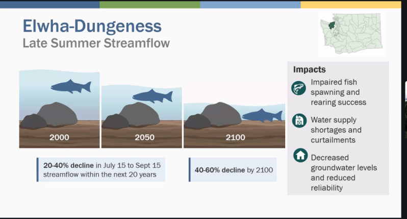
Washington State Department of Ecology slide dated August 4, 2026.
What can we do?
Together, we can become more aware of the facts and reality of climate change and how it will affect our area and our water supplies. Among other sources, these facts are being accurately reported by the Washington Department of Ecology and the Federal Government.
I agree with 3 action items in the CCWD article. We need to work together to conserve water, try to preserve salmon runs, practice good river management and assure adequate and equitable distribution of our limited water resources.
Drought Conditions and Dungeness River Flow Report
Posted 7/28/2026. Post updated 7/30/2026.
Although it seems cool and damp here in Sequim and Clallam County, this area in in a drought and water supplies cannot be taken for granted. I am convinced that Clallam County is one of the most climate resilient counties in the United States. This county does not suffer from the extreme heat, severe droughts nor destructive flooding that other areas of the US are currently enduring. Living here makes it easy to ignore the effects of climate change or even to deny climate change entirely. Nevertheless, this area is subject to the effects of ongoing climate change. Due to low snow pack caused by higher temperatures in the mountain ranges this past winter, runoff levels are very low this year. The area is also in a moderate drought which is forecast to continue.
Snowpack
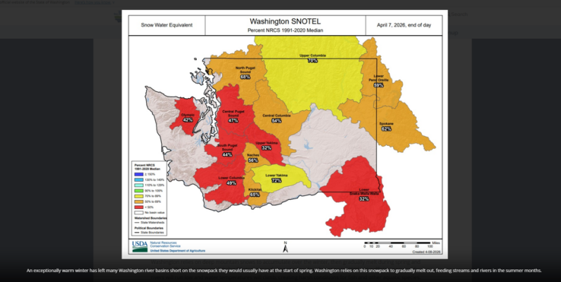
The Washington Department of Ecology issued a statewide drought alert on April 8, 2026. This drought is the result of a dismal snowpack over the winter.
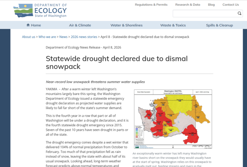
Here is an image of the Washington state snowpack conditions reported in this report.
Drought
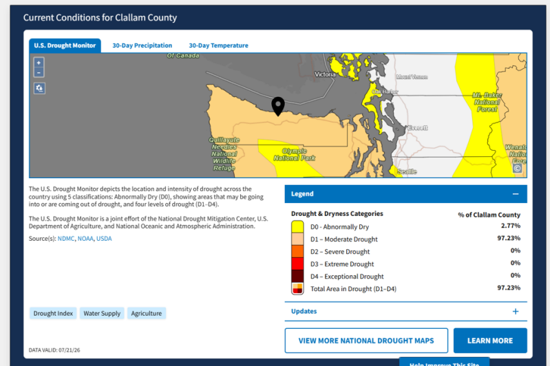
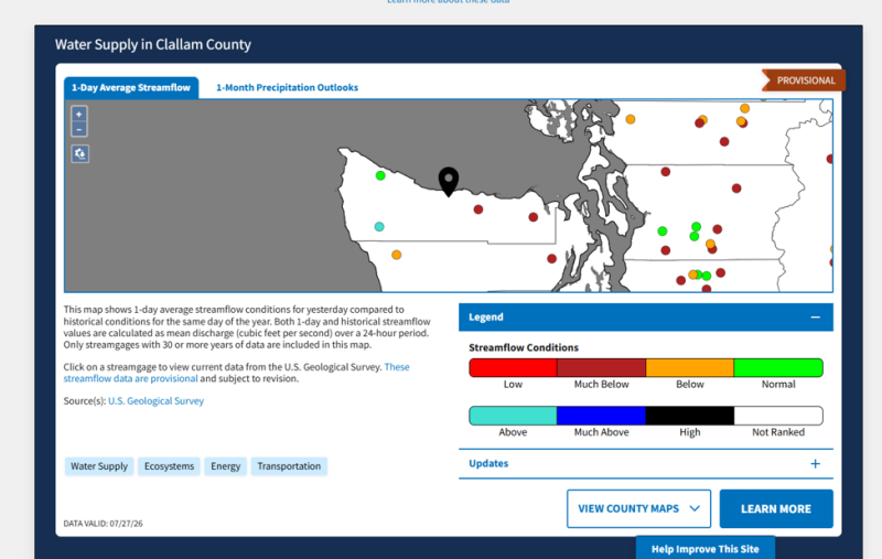
The Federal Drought Information System (FDIS) confirms the Washington State Department of Ecology report. The FDIS reports that Clallam County is currently in a moderate drought; this drought is expected to persist and that current local water supplies are low.

Dungeness River
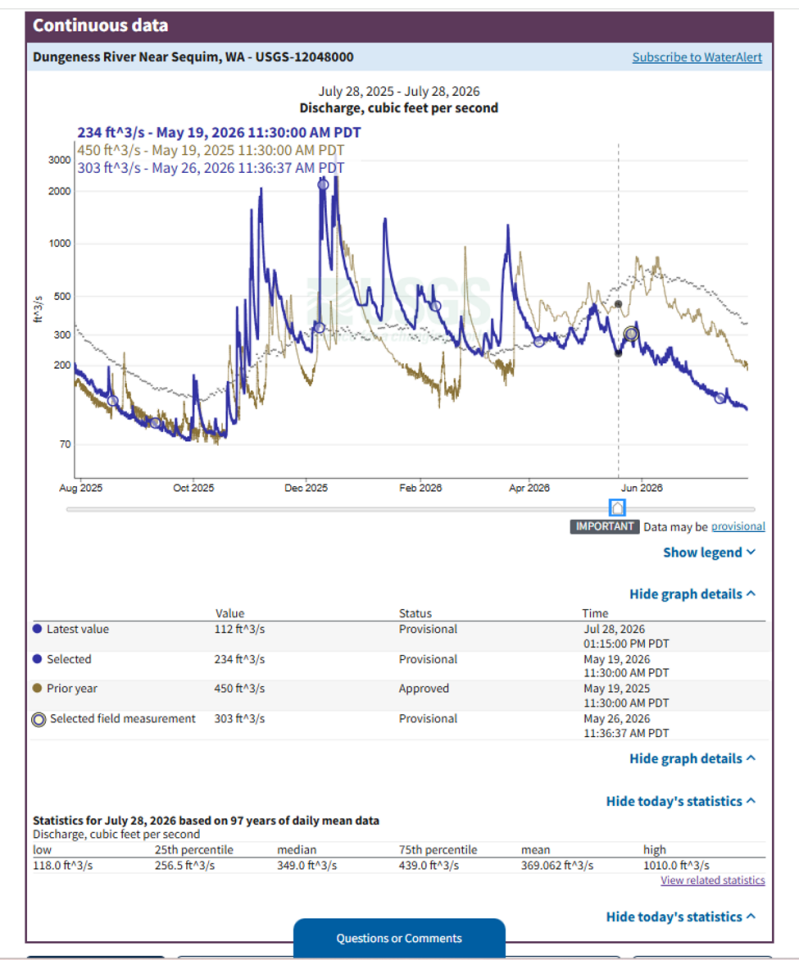
The water flows in the Dungeness River appear to be at historically low levels. One has to be careful about interpreting the reported data, because of the variability of precipitation. (View the graph below.) The dark blue line is this year's water discharge rates. The brown line is last year's discharge rate. and the dotted blue line is the graph of 97 years of accumulated historic discharge data. The current levels are far below the historic average.
Reports in the News Media
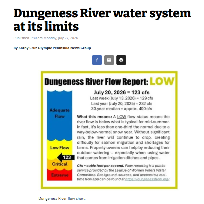
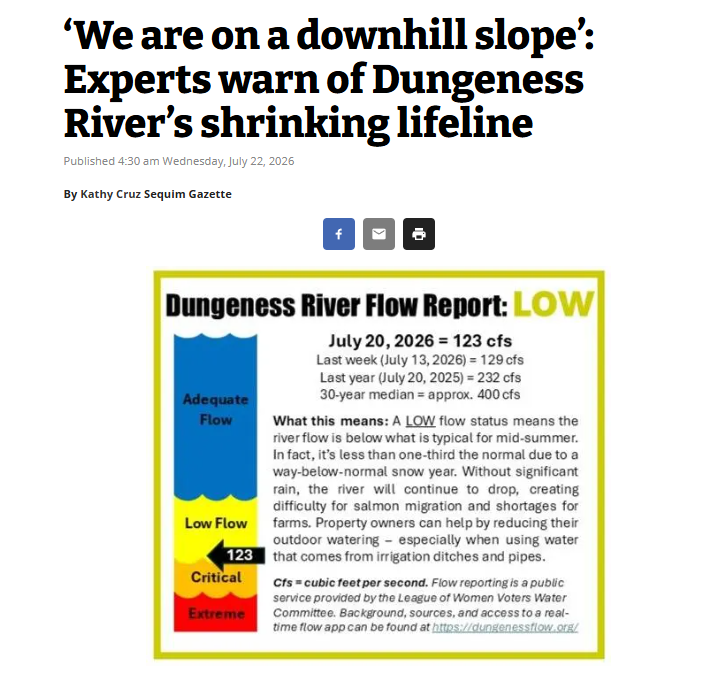
Just recently, a couple of reports have appeared in the Peninsula Daily News. Local experts are reporting the on the low water flows in the Dungeness River and are warning about the causes and effects of this low water flow. The effects are going to be a shortage of water for local irrigators as well as imposing limits on how much water will be available for people moving into the area, and of course, how much water will available to support the local salmon runs each year. The bottom line: it's not an emergency yet, but there definitely will be less water to go around.
Furthermore, the runoff from the local Olympic Mountain Range supplies not only the surface water in the Dungeness River and local creeks, but this runoff also fuels an unseen downhill water flow in the local aquifers, providing water for the many municipal and private wells in the area. The effects of this decreasing water supply on these local aquifers is not well understood yet. It seems prudent to gather data in these local aquifers, including well level trends and take appropriate action to assure a long term supply.
Dungenessflow.org
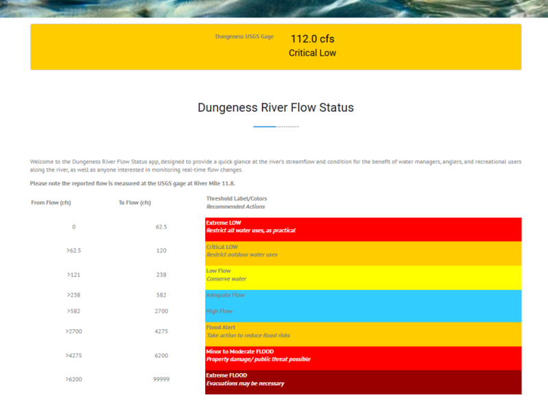
There is a local organization that is dedicated to keeping the public informed about the flow of the Dungeness River. This organization is the Dungenessflow.org website. https://dungenessflow.org/ You can go here and download a mobile app that allows you to check on the latest Dungeness River flow for yourself.
Washington's Water Future
The Washington Department of Ecology is taking action to protect our water future. You can get directly involved. At the site provided below, you can access more information about our water future. Have a look at their Overview Presentation. You too, can provide your input on Washington's Water Future initiative by taking the survey. And you too, are invited to attend an upcoming input session webinar on August 4, 2026.
Protect the Peninsula's Future
There is a local organization dedicated to Protecting the Peninsula's Future. They have six causes and among them is the issue of protecting water.
Public Comment
The following is a public comment submitted to Jennifer Hennessy, the Special Assistant to the Director, Department of Ecology by a local citizen, Tony Corrado.
Public Comment: Reevaluating Water Sustainability and Climate Strategy in the Dungeness Basin
To: Jennifer Hennessey, Special Assistant to the Director, Department of Ecology
Dear Jennifer,
I am submitting these comments in response to the Department of Ecology’s request for feedback regarding Washington State’s long-term water sustainability amidst ongoing drought.
I want to commend the Ecology staff for their recent presentation to the Dungeness River Management Team (DRMT). Their presentation on drought response was exceptional and thoroughly professional. While my insights center primarily on the Dungeness Basin, I recognize that your department must balance these local dynamics with broader statewide policy. My comments are strictly personal. I urge the Department of Ecology to consider the following points:
1. Retire the Term "New Normal"
Framing current climate impacts as a "new normal" creates a false narrative of stability—implying that we have simply transitioned from one predictable climate state to another. Historical patterns can no longer serve as a baseline for future projections. Rather than a settled state, our climate reality is an ongoing, volatile cycle of intensifying weather extremes, severe droughts, and unexpected flooding.
2. Recognize Exponential Climate Acceleration
We have passed the point of gradual change and entered a critical phase where climate impacts are compounding exponentially. Disruptions across all fronts—including extreme temperatures, severe drought, flooding, shifting agricultural seasons, and food supply strain—will continue to worsen year after year.
3. Shift from Standard Operations to Crisis Management
Government bodies at all levels—federal, state, county, and local—are fundamentally unequipped for the velocity of this crisis. Bureaucratic constraints, inadequate staffing, financial limitations, and regulatory hurdles prevent agencies from acting with the required urgency. We cannot treat this as business as usual; it demands emergency protocol.
● Local Case in Point: Clallam County’s Off-channel Reservoir project has dragged on for over 11 years without moving a single yard of dirt, and its location remains unsettled. Worse, the current design is already recognized as insufficient even for basic river recharge needs to protect local salmon runs.
4. Bridge the Public Knowledge Gap on Groundwater Connectivity
There is a dangerous disconnect in how the public and managing agencies view surface water versus groundwater. People often assume these systems operate independently. Consequently, declining snowpacks and winter ice are viewed merely as surface water issues. Public outreach must clearly articulate that direct precipitation is becoming the primary source for both surface and groundwater systems.
5. Overhaul Modern Water Rights
The legacy doctrine of "first in time, first in right" is no longer functional under modern climate realities. Legislative action is necessary to reallocate water rights so that essential needs—such as residential supply, agriculture, livestock, wildlife, and fish habitats—are equitably protected. We must establish a new framework that mandates conservation across all sectors.
Time is running out, and immediate, systemic action is required.
Sincerely,
Anthony Corrado
Sequim Resident